Of patterns for street-names

If there’s anyone who hasn’t yet discontinued their feed for this now-dormant and never-very-interesting blog, here’s a reward: most of the chapter on street-naming from the delightful Names on the Land by George R. Stewart. Enjoy!

First, the owners of the land had it surveyed, and from the survey a plat was drawn up, showing the plan of the streets. Then the owners petitioned the Legislature for incorporation under a certain name, and filed the plat. Generally the streets formed a checkerboard after the model of Philadelphia, and there were seldom fewer than ten each direction, though they might exist only on the plan and still be unbroken forest or a muskrat swamp. Usually from the beginning, these streets bore names. Thus every new town — and there were hundreds of them — required some twenty new names for streets.

No one passed any laws about naming streets, or even wrote a book of advice. As often in democracy, however, the result of complete freedom was not complete chaos. The town-planners tended to repeat traditionally, with slight variation, what was already familiar. So arose the four basic patterns of American street-names, more or less associated with different great cities, which served as models.

First of all, there was the pattern which might be said by paradox to be no pattern. The streets running in both directions bore names, and these followed no system. Boston furnished the model in the farther north. Most of the New England towns copied the Boston names, so that the typical pattern included State Street, Federal Street, and Congress Street, and probably Summer, Winter, Spring, Pleasant, and Commercial.

The older South also named its streets in both directions, taking its chief model perhaps from Baltimore, which became the first large southern city. But, even more than New England, the South held to itself, state by state, and even county by county. So no special series of names ran through the new southern towns. Instead, they more often named their streets for local heroes or plantation-families.

The most truly American pattern, however, remained that of Philadelphia — to have streets designated by numbers in one direction and by names in the other. The Philadelphia pattern spread west into Ohio and Kentucky and beyond. It followed down the Mississippi through Memphis, and took over many of the American-founded towns of Louisiana. It had outposts in New England — Bangor, New Bedford, Pittsfield, and others. It encroached strongly upon Virginia and Tennessee. Even in the farther South it furnished the pattern for many towns, such as Charlotte and Macon.

Like all systems of naming, it offered some problems. Where, for instance, should First Street lie? With a town on a river or lake, the conventional solution was to put First Street along the riverfront. Even so, time might bring difficulties. Often the shallow water was filled in, and First Street was no longer the first. These new streets were conventionally called Water or Front, again the Philadelphia pattern. On the other hand, a town laid out on a riverbank might find First Street caving into the water. Sometimes the river took the whole town, but sometimes only a section, so that perhaps Fourth Street became the first street, as in St. Joseph.

If no body of water was available to give a natural starting-point, First Street was merely placed along one edge of the plat. Then, if the city grew across that line, that part of it had streets which were outside the pattern.

Penn used his cross-streets the names of trees — “that spontaneously grow in the country.” Many founders of towns blindly followed his lead, using Chestnut, Walnut, and Mulberry, without any thought as to whether those trees grew there naturally. The trees, however, gave no indication of the succession of streets, and no order every became conventional. The followers of the Philadelphia system, in fact, never solved this difficulty. In certain regions of Ohio and the states north and west, many towns used the names of the first five Presidents in order. Any American might be expected to know that Monroe was the third street beyond Adams. The election of a second Adams, however, spoiled the system, and the intensified of party strife at the end of the Era of Good Feeling made some of the later Presidents too unpopular.

The planning and naming of the national capital offered a third model for new towns. The whole city was split by two main axes into four sections, designated by the half-points of the compass. East and west of one axis the streets began with First, and so continued. North and south of the other axis the streets began with A Street and continued through the alphabet. Broad diagonal thoroughfares, called avenues, bore the names of the states. The avenues and the alphabetically designated streets were the important innovations.

Although a plan of Washington was published in 1792, its building proceeded slowly and its influence was delayed. Richmond, Indiana, platted in 1816, followed it. In 1821 Alexander Ralston, who had helped with the laying-out of Washington, was appointed to survey the site of Indianapolis, also to be a capital city. He consciously imitated Washington, but in the end Indianapolis showed little of the name-pattern except for a few diagonal avenues named after states.

The Washington plan and name-pattern, both usually simplified, spread on to an occasional Illinois town, across the river to Iowa, and thence north and west. But it was nowhere dominant. The Americans simply did not like it.

One detail only of the Washington-pattern became popular. The French avenue, meaning usually the tree-bordered approach to a country-house, had been used in English for some time. It had even attained rhetorical usage, as when a Revolutionary orator cried out: “Oppression stalked at noon-day through every avenue of your cities!” But let oppression stalk where it might, no American had Avenue as his address until after the founding of Washington. Even the later popularity of Avenue may be partially credited to New York.

In 1807 a Commission was appointed to lay out a plan for the as yet unbuilt parts of Manhattan Island — “The leading streets and great avenues.” On April 1, 1811, the map was finished and filed. It presented the basic plan and name-patter of midtown and uptown New York which by the prestige of the city have become familiar to the whole world. The cross-town streets were numbered, after the Philadelphia fashion. The broad north-south thoroughfares were called Avenues after the Washington fashion; but, again after the Philadelphia fashion, they were numbered successively from First along the East River. The bulge of the island below Twenty-third Street, however, lay east of First Avenue; the Commissioners accommodated this geographical difficulty by the Washington device of using the letters of the alphabet from Avenue A to Avenue D. All the elements of the New York pattern were thus borrowed from Philadelphia and Washington, but their combination was something essentially new. The device of having numbered avenues cross numbered streets avoided the lack of system in the Philadelphia cross-streets. Yet the pattern was simpler than that of Washington.

Americans had been familiar with the Philadelphia pattern for nearly a hundred and fifty years before the New York adaptation even got on paper, and many more years elapsed before the midtown section became important. By that time most of the towns east of the Mississippi had already named their streets. The New York pattern was to be of influence in a few newer eastern towns, and in the newer sections of older cities, and especially in the farther West.

In naming their streets, the Americans were obviously torn between two basic emotions. First, they were a practical people, and vastly admired themselves for being so. Numbered and lettered streets thus attracted them greatly. One writer declared that a good street plan was incomplete:

unless there exists an orderly and methodical system of suitable names, so arranged as to enable the resident and the stranger within its gates to ascertain for themselves and without needless trouble or delay the relative positions of the different highways through which they might be called to pass.

Boston and Baltimore failed entirely to meet this requirement, and were rejected. Washington raised undue complications, and tended to defeat its own object. New York was the ideal of practicality, with the result that of all great cities it remains (with the exception of its downtown district) the easiest for anyone, resident or stranger, to find his way around in. Philadelphia was a compromise.

Its strength lay in that very fact. For, besides being practical, the Americans were like all peoples in having a strong tinge of sentiment in association with names. Names may be poetry; they readily become symbols of patriotism, achievement, or love of home. Numbers and letters sometimes attain symbolic value, but less easily and often.

The Philadelphia pattern allowed sentiment along with practicality, and its success fell little short of an overwhelming triumph. More than half of all our towns, perhaps three-quarters of them, have a system of numbered streets. The numbered avenues, after the model of New York, fail to appear in more than about one in six. About one town in ten shows the Washington pattern of lettered streets. The New York device of Avenue A makes a negligible showing. The repetition of individual street names tells the same story. Chestnut Street is far commoner than Pearl, and Pennsylvania Avenue is hardly in the running.

Thoughts on the 2040 Transportation Policy Plan

I’d been meaning to spend more time digging into the 2040 Transportation Policy Plan, but I’ve been kind of busy with another project, and the due date for comments (today at 5pm) has snuck up on me. There are a couple areas in which I’m concerned but I think I’ll just send in the generic TLC supportive comment because ultimately my concerns are more quibbles than anything. Overall I think the plan makes some significant advances over the 2030 plan, particularly in its consideration of land use and form when evaluating transportation investments. But at the same time the plan is deeply troubling to me, primarily because in the time horizon of the plan I will have reached the end of my middle age (knock on wood) and this plan contemplates a transit system that still cannot be used for daily needs on a citywide scale.

1. Transit Market Areas

This plan makes significant improvements to the important policy known as Transit Market Areas. These areas are actually used to decide where and what kind of transit service is implemented. Briefly, the areas are numbered 1-5 (or I-V in the new plan) and as the area increases numerically the level of service warranted decreases, with the most important break in my opinion coming between areas 2 and 3, the former of which supports usable regular route service and the latter of which does not. The formula used to determine these areas has been updated to include intersection density, a proxy for (and characteristic of) transit-supportive urban design, but at the same time employment density has been demoted in the weighting of the different components of the formula. The result is a map that has changed from the 2030 plan in unsettling ways.

First, the 2030 map:

2030TPPTransitMarketAreasAnd now the 2040 map:

2040TPPTransitMarketAreasIt disturbs me that Area 3 expands in the new map while Area 2 contracts significantly. This represents a decline in the area where it is practical to use transit, since it is extremely difficult to use peak period express service for anything other than a daily commute. This transit-slashing result is due to the use of current figures for population and employment rather than projections. Bloomington is a great example of this, as the Met Council’s 2040 population forecasts predict a 37% increase in the city’s population, an absolute increase of over 30,000 people, and the city’s land use policy directs half of that into the area in the eastern tip that surrounds the Mall of America. Yet the Area 2 actually shrinks out of this growth ghetto in the updated map!

There is a bit of temporal incongruity in the plan’s use of the Transit Market Area map, as despite the fact that this plan is covering the next 26 years, this particular portion is actually supposed to reflect current conditions, be used immediately, and revised as conditions change (I’m not sure how often that actually happens). However, as I noted above the important achievement of this plan is the degree to which it articulates land use and transportation policies. As such, I don’t think it should be unreasonable to recognize the influence that transportation facilities have on land use. So while it would be inadvisable to base current transportation policies solely on future land use, I think it would be wise to include the population (and employment) forecasts in some degree while developing the Transit Market Area policies. After all, what incentive is there to build transit-oriented development in a place with no transit?

One more brief quibble that is illustrated by the new exclusion of the Mall of America’s neighborhood from Transit Market Area 2 is the underweighting of employment density. Again, I think it’s great that intersection density is a factor in determining these areas, but does it really deserve to be weighted higher than employment density? What is more important in the decision to take transit, the relative comfort of taking it or the existence of something to take it to? While both are important, if the latter were all that mattered, would anyone ever take transit in this nation of curb cuts and skinny or nonexistent sidewalks?

For easy reference, here is the relative weighing of the different components of the formula that determines the Transit Market Areas (which they call the Transit Market Index or TMI, which apparently is also Too Much Information for the typical reader of the plan, so they buried it in Appendix G):

𝑇𝑀𝐼=0.64βˆ—(π‘ƒπ‘œπ‘π‘’π‘™π‘Žπ‘‘π‘–π‘œπ‘› 𝐷𝑒𝑛𝑠𝑖𝑑𝑦) +

0.23βˆ—(πΌπ‘›π‘‘π‘’π‘Ÿπ‘ π‘’π‘π‘‘π‘–π‘œπ‘› 𝐷𝑒𝑛𝑠𝑖𝑑𝑦) +

0.20βˆ—(πΈπ‘šπ‘π‘™π‘œπ‘¦π‘šπ‘’π‘›π‘‘ 𝐷𝑒𝑛𝑠𝑖𝑑𝑦) +

0.11βˆ—(π΄π‘’π‘‘π‘œπ‘šπ‘œπ‘π‘–π‘™π‘’ π΄π‘£π‘Žπ‘–π‘™π‘Žπ‘π‘–π‘™π‘–π‘‘π‘¦)

2. “Increased” Revenue

I’m moving away from the Twin Cities in which I was born and raised because of the low quality of the transit system. One of the reasons I’ve stayed as long as I have is that my family is here, but it is frustrating or impossible to visit them without a car, and I’ve grown to realize this is not going to change. The 2040 Transportation Policy Plan confirms this. It plans for broad swathes of the metro area to remain distant from transitways, condemning anyone without a car to the limbo of mile after mile on a lumbering, rambling local or interminable waits and planning your life around extremely infrequent service, or simply not being able to access much of the city.

Of course I’m not saying transportation for the region should be planned around my family, but I do find it strange that this plan has ended up with such little coverage. Interestingly, there is some discussion on pages 246-247 of the factors for determining transitway investment, and regional balance, a form of coverage goal, is included. Unfortunately this seems to mean that at least one transitway should touch each county, which has the bizarre effect of allowing 19th century politics and geography to determine 21st century transportation investments. I would think that if this coverage goal could be included as a factor, there could be something about considering regional employment and retail centers.

Now may be the time to mention that the Current Revenue Scenario vision for transitways is exceedingly bleak:

2040TPPCurrentRevenueTransitwaysThere is a caveat in the plan that it does not include arterial transitways that may be added if the winds of the next 10 years are favorable, but that says nothing about how this vision leaves the vast majority of the metro area, and a significant number of employment centers, completely unserved by transitways and therefore unusable for transit outside of downtown commuting. In what may be an unprecedented move in American planning, it also represents a retrenchment of the transit vision from the 2030 plan:

Of course, the plan also considers an Increased Revenue Scenario, the transitway vision of which is pretty similar to what, in May 2013, the Met Council was planning to have accomplished by 2030:

2040TPPIncreasedRevenueTransitwaysThis vision, while pushing transitways deep into the exurbs, leaves the region’s third largest job center and probably largest retail concentration, Southdale, unserved by rapid transit. Just a couple of years ago, we were considering building light rail to rapidly growing Maple Grove, but this plan doesn’t even consider it worthy of arterial BRT. According to this plan, it will take more than 26 years to figure out how to serve the hundred thousand jobs loosely clustered in industrial districts in Plymouth, Eagan, North St Paul, and Spring Lake Park with some kind of higher-speed transit.

The reasons behind the underwhelming advance in transitway planning deserve deeper reading of the plan that I was able to give. It’s possible that the vision was pared to fit the revenue available under the assumptions of their Increased Revenue Scenario, but I’m not entirely sure what those assumptions are and probably deserve the blame for not being able to interpret the figures given in the plan. If I’m reading it right, the sole difference between the Current and the Increased Revenue Scenarios is that the latter includes a half-cent sales tax increase. I’m unclear about why this number was chosen, since peer cities such as Denver and Salt Lake City have higher transit sales taxes (I think). But I have deeper questions about the assumptions in the Current Revenue Scenario, in which categories such as State Bonds and Property Taxes see declines over the life of the plan despite increases or plateaus in recent history. What am I missing that would account for a 30% drop in property tax revenue. In a political world where we’ve seen the traditionally biennial bonding bill become a yearly feast, why would state bonding support for transit drop? But again, I haven’t had time to give the financial underpinnings of the plan the scrutiny they deserve.

Ultimately this plan represents a major advancement in transportation policy for the region, and as such it deserves support. If you’re interested and have time today, check out David’s and Brendon’s critiques at streets.mn, and if you still feel compelled, submit TLC’s form letter. If you have had more time than I have to spend with this plan, I welcome your corrections, insights, or general comments.

The blog is dead. Long live the blog!

This blog has been stagnant for a couple years now, so maybe I’m typing this message out into an abyss. But if anyone is still reading this, I’d like you to know that I’ve started a new blog and hope to actually update it frequently (at least for the next few months). I quit my job and bought a car (!) and I’m heading down the Mississippi, stopping frequently to walk around and interview the poor suckers I find along the way about their experience walking in whatever place I am. You can read it at mouthofaslough.wordpress.com.

I don’t know yet whether that means I’ll be posting more or less here at gettingaroundmpls blog, but I’m optimistic it’ll be more, especially because it would be hard to post here less that I have been. So be sure to check back here every day to find out…

Bust open the Bottleneck with buses

Last Thursday I threw a post up on streets.mn that proved using mathematics! that the Hennepin-Lyndale Bottleneck is overbuilt as a roadway and could be reduced by a lane in most segments without risking more than moderate congestion. This result fits with my experience as a frequent user of the Bottleneck at rush hour over a period of many years – the freeway-scale design makes it feel like you’re inching through the facility at slug speed, but in reality traffic moves through the Bottleneck no slower than on other nearby urban streets. On top of the space that could be recaptured from the extraneous lanes, the existing lanes are mostly far too wide, so a lot of pavement can be reduced just by rebuilding the lanes at a more appropriate width.

Scroll down for pics!

So what to do with all this extra space? Anyone who glances over the last year or so of posts here, if still awake, can guess what I say: bus lanes. The thousands of bus riders that travel through the Bottleneck could be sped through daily and be insulated from occasional congestion, and those sitting in cars would watch as the buses made it through faster on this highly visible facility, encouraging them to think of transit as a better option. One of the great transportation weaknesses in Minneapolis is that the Devil’s Backbone (the ridge that comprises Lowry and Loring hills) creates a wall that makes it difficult to travel between Downtown and Uptown. It’s in the city’s best interest to encourage as much of that traffic as possible to take place on space-efficient travel modes such as mass transit.

Here is a map-like graphic I used on the streets post to show which segments could lose a lane without risking much congestion:

BottleneckLaneCapacityMinusOneLane

Most of the route along Hennepin is green, indicating that a lane can be removed, and the one segment that isn’t is just barely over the 75% threshold. This segment has an enormous amount of queuing space (650′ for the lanes coming from the Bottleneck and over 2000′ for the lane coming from I-94), so I’d suggest that here too a lane be removed and replaced with a bus lane. Here is a lane diagram of the Bottleneck with extraneous lanes removed and replaced with bus lanes where needed:

BottleneckProposedLaneCount

This provides a bus lane through the entire facility for buses coming to or from South Hennepin, and for much of the facility for Lyndale buses. The bus lanes would also be used for right turns indicated by standard lane symbols, which simply involves a switch from a solid while line to a dashed line shortly before the intersection, along with a right-turn symbol or two. I’ll reproduce an example from British Columbia here, because a lot of Minneapolitans seem to have difficulty picturing this:

The northbound segment just north of Franklin is more tricky, due to traffic exiting to I-94. The bus should still have priority, so I’d recommend striping a short lane for general traffic north of the intersection that is required to merge across the bus lane (yielding to buses in the process) before exiting:

HennepinAtFranklinNorthLegBusLanesThis may seem tight, but there is about 330′ or the length of a downtown block in which to accomplish this, which shouldn’t be a problem for traffic moving at urban speeds (20-25mph). I’ve depicted it within the existing curb-to-curb width, but as the northbound segment is being rebuilt as part of The Project, I’d suggest that the general traffic lanes be reduced to 10.5′ a pop, with the bus lane at 12′, so that it can be reduced 2′ overall and adjacent sidewalk/boulevard made a bit less pathetic/dismal.

As long as we’re discussing the above image, I’ll mention that it depicts the existing southbound roadway, the 34.5′ of which will not be touched as part of The Project. In this space I’ve ruthlessly slashed one of the general traffic lanes and replaced it with an offset bus lane. Additionally I portray the corner with a striped (and bollarded) curb extension, which should be added to every corner on a street with parking as the city’s adopted policy recommends.

It’s possible that something similar could be done on Lyndale at the north leg of the intersection with Franklin. The roadway there happens to be exactly the same width as Hennepin, and the traffic patterns seem to be mostly similar. I think that the city’s policy to reduce VMT is enough to justify replacing a lane in each direction with a bus lane, and additionally this area has been screaming for an extension of the Lyndale bikeway to Franklin (not to mention more pedestrian space, the lack of which forces an awkward dance at the southbound bus stop and taking turns in front of Rudolph’s). If this were to occur, here’s a suggested cross section:

lyndale-ave-s-rebuilt-north-leg-at-franklin

However, there is a much higher volume of vehicles per lane on Lyndale than on the corresponding segment of Hennepin, and anyway this segment of the Bottleneck isn’t going to be rebuilt as part of The Project. It should still be restriped, though, to improve the currently awkward required movements and outrageously overwide lanes. Additionally, the Lyndale bikeway should be extended south by replacing the existing parking lane with a bollard-separated two-way cycle track. Here’s an idea for how this would look:

lyndale-ave-s-restriped-north-leg-at-franklinThis could also improve traffic flow by removing the scary merge of southbound traffic just north of the intersection (technically the traffic from I-94 is supposed to yield but they often don’t). It would do this by replacing one of the lanes of Bottleneck traffic with a bus lane, then giving each stream their own lane at the intersection and banning Bottleneck traffic from turning left (they have had plenty of opportunities to travel in that direction already). Here is a diagram:

SouthLyndaleRestripeLaneDiagramThis plan reduces capacity as measured by square feet of pavement, but I think it will actually improve traffic flow by reducing conflict points and increasing clarity about where to go (note how the northbound lanes now have one clear lane to get in that will take them either to Hennepin or to Lyndale & the freeways). I’ll point out that here too there is enormous queuing space, so dozens of cars could pile up (er, behind, not on top of each other) before impacting an intersection.

If you look back to my overall lane diagram above, there are a few other places where reducing a lane actually has the potential to aid the flow of traffic by making destination more clear. The southbound lanes are an example; currently the four lanes are ambiguous about which will go where, but if you cut a lane it’ll be one destination per lane, from left to right: 15th/I-94, Lyndale, Hennepin. The other spot improved by a lane reduction is the northbound lanes where it splits into Hennepin vs. Lyndale/freeways. Currently one of the lanes splits into both destinations, making the signage confusing. Since Hennepin downtown has been reduced to two lanes inbound, there’s absolutely no need for three lanes to split off the Bottleneck here, so I’d say do one general traffic lane to Hennepin that can be flared out to two at the intersection if necessary.

As you may have noticed, my plan mostly doesn’t actually reduce the number of lanes, but rather replaces some lanes with bus lanes. But there are many other changes needed along the Bottleneck, such as improving the space for bikes and peds and general greening, all of which requires space to do. Amazingly, the current lanes are so overbuilt that even assuming one of the current lanes in each direction is replaced with a 12′ bus lane, by reducing the remaining lanes to 10.5′ a substantial amount of space can be captured (zoom your eyes to the 4th & 5th columns from the right):

BottleneckLaneWidthsNote that each line of the chart indicates only one direction, so that for most of the segments, at least 10′ can be converted to bike/ped space or green buffers. Also, my analysis hasn’t even touched on the pointless “access” road between Groveland and Douglas, which could be eliminated altogether but at least could be substantially narrowed for a significant aesthetic improvement and public gathering space.

Public works has promised to release their latest design for the reconstruction at a public meeting on August 4th. I’m hopeful that they will use the space gained from narrowing lanes to separate the bike & ped streams along the Loring Bikeway, and my best case scenario is that one of the obviously superfluous lanes heading to Hennepin downtown will be dropped. But aside from that I don’t expect any substantial changes, in part because of Public Works’ continued auto-orientation but also because of the rumor I mentioned in the streets post that got so much attention in the comments. Rebuilding the Bottleneck substantially the same would be a tragedy for Minneapolis, not only because it dooms the city to decades more of unpleasant, auto-centric commutes but because it is a huge opportunity lost for a great central public space. If this occurs, rest assured I will expound on this rumor and call to account those responsible for the tragedy.

Postlude, because I really haven’t written enough yet: I of course think that the freeway ramp overpasses should be torn down and replaced with surface facilities like a roundabout or traffic circle, thus freeing up developable space as well as providing room for much greater pedestrian connectivity and cycletracks throughout. The plans shown here operate only within the constraints of the current reconstruction project, which do not allow us to ponder changing the freeway interchange, possibly with the ulterior motive of requiring their continued presence.

The last 16 years of Minneapolis bikeways in one seizure-inducing gif

I posted the following map on streets.mn today, which I’d made from a powerpoint presentation to the Transportation & Public Works committee a few weeks ago:

MplsBikeways1997-2003

It’s amazing to look back at 2001, when I started riding, and see how few lanes there were. We got by somehow, but it wasn’t easy or much fun at all. I made extensive use of all the contraflow lanes that used to be downtown, on Marquette & 2nd and on Hennepin. The former worked pretty nice actually, and in a lot of ways were better than the current Marq-2 configuration (in that there was actually accommodation for bikes). But the Hennepin lanes, which I guess you could call an “on-street, unprotected cycletrack”, were among the more terrifying facilities I’ve ridden. If you were heading towards the river you would nearly always overtake a car waiting to turn left, proceeding on a wing and a prayer that the driver was paying attention to what was behind them as well as what was in front of them. Even the pathetic green lanes are better than that, and the 1st Ave protected lanes are mostly much better.

Today’s network is much more impressive, especially on the Northside and around the U. But still much of the city has merely nominal facilities, like Linden Hills and Far Southwest or Northeast, and Nokomis and Longfellow have none at all. Additionally, most of the lanes are unprotected and the MPD shows little or no interest in enforcing them, so riding in a lane means frequent detours into general traffic lanes. On a recent Monday afternoon (not yet rush hour) ride on the 1st & Blaisdell facilities, I encountered six obstructions in about two miles. At that point you fail to have useful facilities.

Minneapolis has devoted a lot of wind energy (i.e. words) to making Minneapolis a great biking city, and these maps could be used as evidence that the plan is succeeding. But the conditions on the street don’t show significant improvement from 2001, and unless either the protected bikeways goal is vastly exceeded (30 miles represents only about 15% of the current, inadequate total bikeway mileage) or Minneapolitans get a lot nicer about respecting bike lanes, biking in Minneapolis will remain a much better talking point than a lifestyle.


The city we’re all looking for

From The Golden Age by Kenneth Grahame:

ALL the roads of our neighbourhood were cheerful and friendly, having each of them pleasant qualities of their own; but this one seemed different from the others in its masterful suggestion of a serious purpose, speeding you along with a strange uplifting of the heart. The others tempted chiefly with their treasures of hedge and ditch; the rapt surprise of the first lords-and-ladies, the rustle of a field-mouse, splash of a frog; while cool noses of brother-beasts were pushed at you through gate or gap. A loiterer you had need to be, did you choose one of them,β€”so many were the tiny hands thrust out to detain you, from this side and that. But this other was of a sterner sort, and even in its shedding off of bank and hedgerow as it marched straight and full for the open downs, it seemed to declare its contempt for adventitious trappings to catch the shallow-pated. When the sense of injustice or disappointment was heavy on me, and things were very black within, as on this particular day, the road of character was my choice for that solitary ramble, when I turned my back for an afternoon on a world that had unaccountably declared itself against me.

“The Knights’ Road,” we children had named it, from a sort of feeling that, if from any quarter at all, it would be down this track we might some day see Lancelot and his peers come pacing on their great war-horses,β€”supposing that any of the stout band still survived, in nooks and unexplored places. Grown-up people sometimes spoke of it as the “Pilgrims’ Way”; but I didn’t know much about pilgrims,β€”except Walter in the Horselberg story. Him I sometimes saw, breaking with haggard eyes out of yonder copse, and calling to the pilgrims as they hurried along on their desperate march to the Holy City, where peace and pardon were awaiting them. “All roads lead to Rome,” I had once heard somebody say; and I had taken the remark very seriously, of course, and puzzled over it many days. There must have been some mistake, I concluded at last; but of one road at least I intuitively felt it to be true. And my belief was clinched by something that fell from Miss Smedley during a history lesson, about a strange road that ran right down the middle of England till it reached the coast, and then began again in France, just opposite, and so on undeviating, through city and vineyard, right from the misty Highlands to the Eternal City. Uncorroborated, any statement of Miss Smedley’s usually fell on incredulous ears; but here, with the road itself in evidence, she seemed, once, in a way, to have strayed into truth.

Rome! It was fascinating to think that it lay at the other end of this white ribbon that rolled itself off from my feet over the distant downs. I was not quite so uninstructed as to imagine l could reach it that afternoon; but some day, I thought, if things went on being as unpleasant as they were now,β€”some day, when Aunt Eliza had gone on a visit,β€”we would see.

I tried to imagine what it would be like when I got there. The Coliseum I knew, of course, from a woodcut in the history-book: so to begin with I plumped that down in the middle. The rest had to be patched up from the little grey market-town where twice a year we went to have our hair cut; hence, in the result, Vespasian’s amphitheatre was approached by muddy little streets, wherein the Red Lion and the Blue Boar, with Somebody’s Entire along their front, and “Commercial Room” on their windows; the doctor’s house, of substantial red-brick; and the facade of the New Wesleyan Chapel, which we thought very fine, were the chief architectural ornaments: while the Roman populace pottered about in smocks and corduroys, twisting the tails of Roman calves and inviting each other to beer in musical Wessex. From Rome I drifted on to other cities, dimly heard ofβ€”Damascus, Brighton (Aunt Eliza’s ideal), Athens, and Glasgow, whose glories the gardener sang; but there was a certain sameness in my conception of all of them: that Wesleyan chapel would keep cropping up everywhere. It was easier to go a-building among those dream-cities where no limitations were imposed, and one was sole architect, with a free hand. Down a delectable street of cloud-built palaces I was mentally pacing, when I happened upon the Artist.

He was seated at work by the roadside, at a point whence the cool large spaces of the downs, juniper-studded, swept grandly westwards. His attributes proclaimed him of the artist tribe: besides, he wore knickerbockers like myself,β€”a garb confined, I was aware, to boys and artists. I knew I was not to bother him with questions, nor look over his shoulder and breathe in his earβ€”they didn’t like it, this genus irritabile; but there was nothing about staring in my code of instructions, the point having somehow been overlooked: so, squatting down on the grass, I devoted myself to a passionate absorbing of every detail. At the end of five minutes there was not a button on him that I could not have passed an examination in; and the wearer himself of that homespun suit was probably less familiar with its pattern and texture than I was. Once he looked up, nodded, half held out his tobacco pouch,β€”mechanically, as it were,β€”then, returning it to his pocket, resumed his work, and I my mental photography.

After another five minutes or so had passed he remarked, without looking my way: “Fine afternoon we’re having: going far to-day?”

“No, I’m not going any farther than this,” I replied; “I WAS thinking of going on to Rome but I’ve put it off.”

“Pleasant place, Rome,” he murmured; “you’ll like it.” It was some minutes later that he added: “But I wouldn’t go just now, if I were you,β€”too jolly hot.”

“YOU haven’t been to Rome, have you?” I inquired.

“Rather,” he replied, briefly; “I live there.”

This was too much, and my jaw dropped as I struggled to grasp the fact that I was sitting there talking to a fellow who lived in Rome. Speech was out of the question: besides, I had other things to do. Ten solid minutes had I already spent in an examination of him as a mere stranger and artist; and now the whole thing had to be done over again, from the changed point of view. So I began afresh, at the crown of his soft hat, and worked down to his solid British shoes, this time investing everything with the new Roman halo; and at last I managed to get out: “But you don’t really live there, do you?” never doubting the fact, but wanting to hear it repeated.

“Well,” he said, good-naturedly overlooking the slight rudeness of my query, “I live there as much as l live anywhere,β€”about half the year sometimes. I’ve got a sort of a shanty there. You must come and see it some day.”

“But do you live anywhere else as well?” I went on, feeling the forbidden tide of questions surging up within me.

“O yes, all over the place,” was his vague reply. “And I’ve got a diggings somewhere off Piccadilly.”

“Where’s that?” I inquired.

“Where’s what?” said he. “Oh, Piccadilly! It’s in London.”

“Have you a large garden?” I asked; “and how many pigs have you got?”

“I’ve no garden at all,” he replied, sadly, “and they don’t allow me to keep pigs, though I’d like to, awfully. It’s very hard.”

“But what do you do all day, then,” I cried, “and where do you go and play, without any garden, or pigs, or things?”

“When I want to play,” he said, gravely, “I have to go and play in the street; but it’s poor fun, I grant you. There’s a goat, though, not far off, and sometimes I talk to him when I’m feeling lonely; but he’s very proud.”

“Goats ARE proud,” I admitted. “There’s one lives near here, and if you say anything to him at all, he hits you in the wind with his head. You know what it feels like when a fellow hits you in the wind?”

“I do, well,” he replied, in a tone of proper melancholy, and painted on.

“And have you been to any other places,” I began again, presently, “besides Rome and Piccy-what’s-his-name?”

“Heaps,” he said. “I’m a sort of Ulyssesβ€”seen men and cities, you know. In fact, about the only place I never got to was the Fortunate Island.”

I began to like this man. He answered your questions briefly and to the point, and never tried to be funny. I felt I could be confidential with him.

“Wouldn’t you like,” I inquired, “to find a city without any people in it at all?”

He looked puzzled. “I’m afraid I don’t quite understand,” said he.

“I mean,” I went on eagerly, “a city where you walk in at the gates, and the shops are all full of beautiful things, and the houses furnished as grand as can be, and there isn’t anybody there whatever! And you go into the shops, and take anything you wantβ€”chocolates and magic lanterns and injirubber ballsβ€”and there’s nothing to pay; and you choose your own house and live there and do just as you like, and never go to bed unless you want to!”

The artist laid down his brush. “That WOULD be a nice city,” he said. “Better than Rome. You can’t do that sort of thing in Rome,β€”or in Piccadilly either. But I fear it’s one of the places I’ve never been to.”

“And you’d ask your friends,” I went on, warming to my subject,β€””only those you really like, of course,β€”and they’d each have a house to themselves,β€”there’d be lots of houses,β€”and no relations at all, unless they promised they’d be pleasant, and if they weren’t they’d have to go.”

“So you wouldn’t have any relations?” said the artist. “Well, perhaps you’re right. We have tastes in common, I see.”

“I’d have Harold,” I said, reflectively, “and Charlotte. They’d like it awfully. The others are getting too old. Oh, and Marthaβ€”I’d have Martha, to cook and wash up and do things. You’d like Martha. She’s ever so much nicer than Aunt Eliza. She’s my idea of a real lady.”

“Then I’m sure I should like her,” he replied, heartily, “and when I come toβ€”what do you call this city of yours? Nepheloβ€”something, did you say?”

“Iβ€”I don’t know,” I replied, timidly. “I’m afraid it hasn’t got a nameβ€”yet.”

The artist gazed out over the downs. “‘The poet says, dear city of Cecrops;'” he said, softly, to himself, “‘and wilt not thou say, dear city of Zeus?’ That’s from Marcus Aurelius,” he went on, turning again to his work. “You don’t know him, I suppose; you will some day.”

“Who’s he?” I inquired.

“Oh, just another fellow who lived in Rome,” he replied, dabbing away.

“O dear!” I cried, disconsolately. “What a lot of people seem to live at Rome, and I’ve never even been there! But I think I’d like MY city best.”

“And so would I,” he replied with unction. “But Marcus Aurelius wouldn’t, you know.”

“Then we won’t invite him,” I said, “will we?”

I won’t if you won’t,” said he. And that point being settled, we were silent for a while.

“Do you know,” he said, presently, “I’ve met one or two fellows from time to time who have been to a city like yours,β€”perhaps it was the same one. They won’t talk much about itβ€”only broken hints, now and then; but they’ve been there sure enough. They don’t seem to care about anything in particularβ€”and every thing’s the same to them, rough or smooth; and sooner or later they slip off and disappear; and you never see them again. Gone back, I suppose.”

“Of course,” said I. “Don’t see what they ever came away for; I wouldn’t,β€”to be told you’ve broken things when you haven’t, and stopped having tea with the servants in the kitchen, and not allowed to have a dog to sleep with you. But I’ve known people, too, who’ve gone there.”

The artist stared, but without incivility.

“Well, there’s Lancelot,” I went on. “The book says he died, but it never seemed to read right, somehow. He just went away, like Arthur. And Crusoe, when he got tired of wearing clothes and being respectable. And all the nice men in the stones who don’t marry the Princess, ‘cos only one man ever gets married in a book, you know. They’ll be there!”

“And the men who never come off,” he said, “who try like the rest, but get knocked out, or somehow miss,β€”or break down or get bowled over in the melee,β€”and get no Princess, nor even a second-class kingdom,β€”some of them’ll be there, I hope?”

“Yes, if you like,” I replied, not quite understanding him; “if they’re friends of yours, we’ll ask ’em, of course.”

“What a time we shall have!” said the artist, reflectively; “and how shocked old Marcus Aurelius will be!”

The shadows had lengthened uncannily, a tide of golden haze was flooding the grey-green surface of the downs, and the artist began to put his traps together, preparatory to a move. I felt very low; we would have to part, it seemed, just as we were getting on so well together. Then he stood up, and he was very straight and tall, and the sunset was in his hair and beard as he stood there, high over me. He took my hand like an equal. “I’ve enjoyed our conversation very much,” he said. “That was an interesting subject you started, and we haven’t half exhausted it. We shall meet again, I hope.”

“Of course we shall,” I replied, surprised that there should be any doubt about it.

“In Rome, perhaps?” said he.

“Yes, in Rome,” I answered, “or Piccy-the-other-place, or somewhere.”

“Or else,” said he, “in that other city,β€”when we’ve found the way there. And I’ll look out for you, and you’ll sing out as soon as you see me. And we’ll go down the street arm-in-arm, and into all the shops, and then I’ll choose my house, and you’ll choose your house, and we’ll live there like princes and good fellows.”

“Oh, but you’ll stay in my house, won’t you?” I cried; “wouldn’t ask everybody; but I’ll ask YOU.”

He affected to consider a moment; then “Right!” he said: “I believe you mean it, and I WILL come and stay with you. I won’t go to anybody else, if they ask me ever so much. And I’ll stay quite a long time, too, and I won’t be any trouble.”

Upon this compact we parted, and I went down-heartedly from the man who understood me, back to the house where I never could do anything right. How was it that everything seemed natural and sensible to him, which these uncles, vicars, and other grown-up men took for the merest tomfoolery? Well, he would explain this, and many another thing, when we met again. The Knights’ Road! How it always brought consolation! Was he possibly one of those vanished knights I had been looking for so long? Perhaps he would be in armour next time,β€”why not? He would look well in armour, I thought. And I would take care to get there first, and see the sunlight flash and play on his helmet and shield, as he rode up the High Street of the Golden City.

Meantime, there only remained the finding it,β€”an easy matter.


Prove you’re not a hypocrite, Betsy Hodges

Betsy Hodges’ remarks on SWLRT, delivered at the vote today on the staff recommendation for the Kenilworth corridor and freight reroute, strike me as hypocritical at best, childish at worst. She castigates the staff recommendation as entirely favoring St Louis Park (although acknowledging that SLP opposes freight rail proximity to station locations), but the “other, better alternatives” Hodges has publicly acknowledged are freight rail relocation alternatives, which, of course, only favor Minneapolis. So it’s duplicitous of her to imply she wants a compromise.

Now I can understand that as mayor of Minneapolis she wouldn’t want a compromise, but one thing she should want and claims to want is LRT. Her position opposing the staff recommendation carries the very real risk of stopping the SWLRT project, which is the only remaining opportunity in this region for massively improving transit in one fell swoop. Bottineau, Gateway, Rush Line and of course the streetcars are all peanuts without SWLRT, and probably depend on its completion for their success.

If Hodges had any record whatsoever of supporting transit in any way, I might believe her that she supports transit but is opposed to this particular project. But in every transportation decision that she’s had any part in, no mode but driving has been advanced in any significant way, so it seems more likely to me that Hodges is just another suburban politician blowing smoke to get the urban vote, all too common in Minneapolis (cough RT cough). The real test will be municipal consent, of course, but I don’t see any reason to celebrate a statement that opposes a badly needed step towards improving transit in the Twin Cities, and appears to do so for entirely parochial reasons.

In her short mayoralty, Hodges’ primary accomplishment seems to have been finding $1m to make driving in Minneapolis even easier. If she’s serious about transit, she has one of two options:

  • actually come up with an alternative that would somehow both please Saint Louis Park and Minneapolis, despite the fact that their disagreement is essentially binary; or
  • recognize that the immense benefits of SWLRT overshadow the minor problems with the Kenilworth route, that the legitimate process issues she identified in her remarks are can now only be useful to bring up as teachable moments, that a real leader would be gracious rather than petty in defeat, and lead her people towards the next step of mitigating their losses but also accepting the benefits of the situation, which in this case are substantial.

How Hodges speaks leading up to the municipal consent vote could make a difference, but to make these hypocritical remarks in the face of certain defeat, and then to publicize them, doesn’t give me hope that she’ll grow up, let alone act like the leader of a major American city.

4/3 update: Laura Yuen’s piece for MPR diminishes what little hope I had that Hodges will suck it up and do the right thing:

Andy Hestness, vice president of the Native American Community Development Institute in the Phillips neighborhood, suggested dropping the northern tunnel to preserve the 21st Street station, which he said is the best way Franklin Avenue buses in south Minneapolis could access the proposed light-rail line.

“It’s all about connectivity,” Hestness said.

Some committee members, eager to shave up to $60 million by eliminating one of the tunnels, seized on the idea. They asked Hodges her thoughts on the plan, but she said defending the shallow tunnels in any form put her in a difficult position.

The difficult position to which Hodges refers is, of course, deviating in any way from the position of the wealthy DFL donors that live along Kenilworth.

The Turmoil

Just finished The Turmoil, a fierce roar from a hardened lamb named Booth Tarkington who with it attempted to to take down the American heartland of 1914 and very nearly succeeded. For us transpo dorks, it contains fascinating descriptions of a society coming to grips with its recent surrender of safety, community and sanity to its new overlord automobile:

There was a heavy town-fog that afternoon, a smoke-mist, densest in the sanctuary of the temple. The people went about in it, busy and dirty, thickening their outside and inside linings of coal-tar, asphalt, sulphurous acid, oil of vitriol, and the other familiar things the men liked to breathe and to have upon their skins and garments and upon their wives and babies and sweethearts. The growth of the city was visible in the smoke and the noise and the rush. There was more smoke than there had been this day of February a year earlier; there was more noise; and the crowds were thicker – yet quicker in spite of that. The traffic policemen had a hard time, for the people were independent – they retained some habits of the old market-town period, and would cross the street anywhere and anyhow, which not only got them killed more frequently than if they clung to the legal crossings, but kept the motormen, the chauffeurs, and the truck-drivers in a stew of profane nervousness. So the traffic policemen led harried lives; they themselves were killed, of course, with a certain periodicity, but their main trouble was that they could not make the citizens realize that it was actually and mortally perilous to go about their city…

There’s something sort of naive and juvenile in his determination to make this charging, heaving, American machine take a breath and a look in the mirror, but he does it with a passion that’s charming. Worth a read.

ps he’s the guy who wrote The Magnificent Ambersons, which Orson Welles later filmified.

Why isn’t anyone talking about an Olson Memorial Bikeway?

Some people think that Minneapolis has more than enough off-street bikeways. I’m not one of those people. Though I’ve been cycling the mean, car-choked streets of this city for over ten years, I’m never more comfortable on two wheels than when I’m on one of our off-street trails. Streets are intrinsically pervasive, so there are only so many opportunities for off-street infrastructure, and I’m not holding out for the day when the entirety of all my trips are in the comfort of an off-street bikeway.

But where there is potential for development of an off-street bikeway, it should be snatched up. That’s why I’m puzzled that no one has mentioned the idea of building a bikeway along Olson Memorial Hwy. It should be a no-brainer – long segments of this road have wide open space buffers along them that are currently used for absolutely nothing (with the exception of one pigeon perch). Where the open space buffer (obviously intended as future interchange space) is missing, there’s a 30′ wide frontage road, which can easily give up 10′ for a two-way lane separated with candlestick bollards (the aerial google had up as of this writing shows exactly 8 parked cars on the 4500′ of frontage road on the south side of the highway west of I-94). So substantial segments of this bikeway (around half) would be separated enough to have the feel of an off-street bikeway.

morgan-knox olson bikeway

The I-94 overpass is a trouble spot, as MnDot built it with 105′ of roadway and only 15′ for sidewalks (7.5′ on each side). There is a significant amount of right-turning traffic onto the frontage roads on either side, though, so it seems like one of the through lanes could be converted into a second right turn lane, allowing the through lane on the overpass itself to become a two-way lane. The eastbound outside lane appears to be 14′ wide, which would allow a nice buffer.

i-94 overpass olson bikeway

East of I-94 it gets a bit tighter. The open space buffers are ample for the first block, but after that it’s hampered by a bank drive thru on the north and another road on the south. Still, there are options here. In the short term, one of the lanes from the horrible frontage road stump of Royalston can be used for a two-way cycle track. If some engineer demands two lanes at the intersection, the center line can be moved and one eastbound lane reallocated to westbound (or whatever direction you want to call it). Royalston, after all, gets by with one lane in each direction for the rest of its short length, so it should be fine here. In the long term, however, this area should be reconfigured so that the frontage road stump of Royalston no longer exists. Here’s my idea for how to do that, or here’s what the Southwest Transitway Station Area Planning process came up with.

olson royalston bikeway

A curb cut will need to be built to connect to and across 7th St, probably using the huge porkchop island to cross into the HERC block. At that point it’s within the boundaries of the Interchange project, another long stretch of government-owned land that seems to have been planned with no consideration of locating bike facilities there. It’s been hard to find a detailed or consistent site plan for this project, but this one is the latest I know of. There appears to be a good chunk of open space, probably underneath a future Bottineau viaduct, on which to site a 12′ trail approaching from the west. Depending on how the grades end up working, the trail could then share space with one of the redundant motor vehicle access points, leaving only a short gap of what is presumably open space to connect to another motor vehicle access point. There may be a few tight squeezes here, but brain power is cheaper and usually even easier than buying power, so overall this is an excellent opportunity.

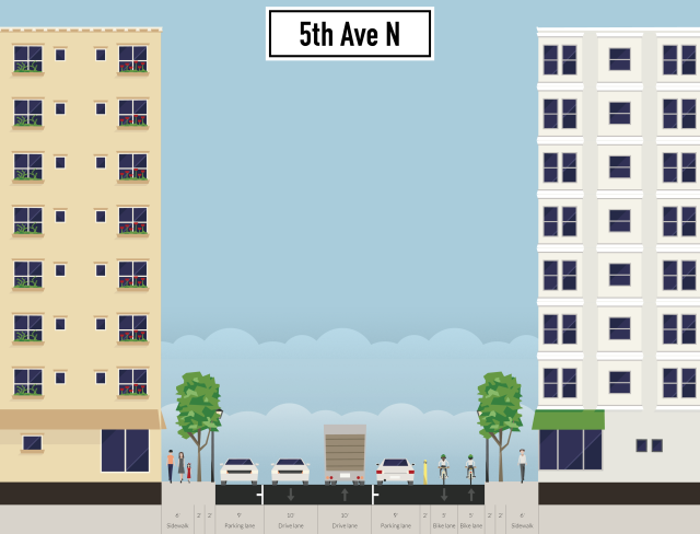
Moving across 5th St, it would have been nice to reserve some space on the Shapco block for bikeway, but it seems that they needed to maximize the amount of grey and beige they could fit on that site. There should be enough space on 5th Ave N, though, as the existing roadway is about 50′ wide. That leaves room for 18-19′ thru + parking lanes (the existing parking lanes are 8-9′ wide) with 12′ for a two-way bikeway with a bollarded buffer. The tricky part here is the rough paving surface – it looks like it’s just asphalt that’s been laid on top of brick haphazardly throughout the years. Hopefully they could do another layer on top for a temporary fix, but if not, it’ll be a long wait before the street is reconstructed since it’s not on the CLIC report at all.

5th-ave-n

The next segment is most iffy part of the whole proposal. The bikeway would need to cross the huge chasm created by the I-394 stump and the Cut. There is, of course, an existing pedestrian bridge, but it’s only 6 or 7′ wide, so would either need to be a dismount zone (yeah right) or extensively modified. It may be possible to cantilever the existing ped bridge – I don’t have a solid grip on this process, but I believe it has been done on this type of bridge (concrete girder) before. If 5′ could be added, it would still be a bit narrow, but doable. Unfortunately no amount of cantilevering will fix the squeeze point at 2nd Ave N, where the ped space is shoehorned into 6′ between a building and a concrete wall. I’m hopeful that eventually the road space allocated to the viaduct here can be reduced, especially since much of it seems to be going to a merging lane that ends before long anyway, but that is certainly a long-term prospect.

After that we’re in the home stretch. 3rd & 4th Sts already comprise a bikeway known as the Hiawatha Trail extension. I can’t leave well enough alone, or rather, I think we deserve better, so I would advocate for protected facilities here to replace the existing paint stripe. Any type of protection will do, but I have a thing for the type of curb-separated two-way bikeway popularized in Montreal (and since spread to Seattle). These are generally better than protected one-way lanes because of their size (i.e. 14′ or so rather than 8′ or so). This makes them more visible, which makes them more legible to users, easier to understand and avoid for other roadway users, and it also makes it possible to plow with standard equipment.Β  When the alternative would be a one-way protected lane on each roadway of a one-way couplet, it also is more legible in that you can just assume the facility is on one street rather than have to keep track of which direction is on which street.

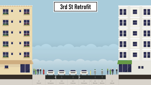
I’m not aware of any near-term plans to rebuild 3rd St, so it would have to be retrofitted to handle this facility. This can be done by reducing it to two traffic lanes, which should be done throughout Downtown to maximize the comparative advantage of transit, biking and walking (Minneapolis has an extremely high private car mode share for its job density). Then lanes can be slimmed to provide about 15′ for a two-way bikeway with a candlestick bollard buffer.

3rd-st-retrofit

When the street is reconstructed, the sidewalks should be widened to at least 15′ to accommodate the streetlife that hopefully will someday exist here. Then a parking lane should be dropped, since terminal facility availability and cost are a big part of that crazy huge private car mode share. We still have room for an ample bikeway, with two through lanes and a parking lane to ensure the smooth flow of traffic. 3rd-st-rebuiltIf all the elements I’ve discussed here are carried out, Minneapolis could have a high-quality, low-stress, legible bikeway bisecting the city. Cyclists would have a comfortable, no-turn ride from Wirth Park to Minnehaha Park. Even if the connection over I-394 and the Cut are found to be unfeasible, a bikeway along Olson would still connect to the wide bike lanes on 7th St, providing an excellent route through Near North. But none of that will happen until the conversation starts, and maybe I’ve done that with this post.